
New Zealand Part 6: Ball Pass Crossing and the Southern Coast
The past few weeks were jam-packed full of hiking and backpacking so we took a few rest days off to visit the Southern Coast of the South Island.
We booked an airbnb in Riverton, outside of Invercargill, for Grady’s birthday. It was a cute tiny home type airbnb with a great outdoor patio that had a distant view of the ocean. Riverton is at 46.3 degrees south which is way further south than the tip of Africa! It’s a big fishing town so we ate at local seafood restaurant on the water and it didn’t disappoint!


We wanted to come to the Southern Coast to see the rugged coastline, visit a few lighthouses, and see penguins. I’ve been really excited to see penguins for our whole trip so we were thinking this was our opportunity.
I did some research ahead of time on the best beaches for penguins, but I didn’t fully appreciate through this research just how rare this type of penguin is. The local penguins here are the Hoiho Yellow-Eyed Penguins. Turns out, they are the rarest penguin in the world and there are only 300 mated pairs remaining in New Zealand.
We learned this while we were waiting at Curio Bay viewing platform for the penguins. I had read that this was a great spot to see them so we had high hopes. The penguins go out to sea to fish all day and then they bring back food to their babies in the nests onshore around sunset. Sometimes they return to the nests a few hours before sunset and sometimes long after sunset - it’s a bit of a gamble. We’d been there for about two hours before someone casually mentioned that there was only one nest (aka two penguins) at this beach.
It wasn’t quite our dream of seeing dozens of penguins waddling back ashore at sunset, but we did see a single Hoiho baby penguin just waiting in the bush. Like the baby penguin, the 40 tourists equipped with telephoto lenses and binoculars, were waiting for the parent penguins to waddle back onshore. It was great to see one, but after 4 hours of sitting in silence on this viewing platform with a bunch of other people we were hoping to have seen one or more in action instead of standing motionless in the bushes. Maybe next time!


The Southland district along the coast is very scenic, but very rural. We stopped at one of the few gas stations to fill up, but the machine wouldn’t take any of our international credit cards. It was a Sunday so there wasn’t anybody working at the station. Thankfully, this man who looked like he captained a very large ship saved the day. We gave him cash and he used his local card.
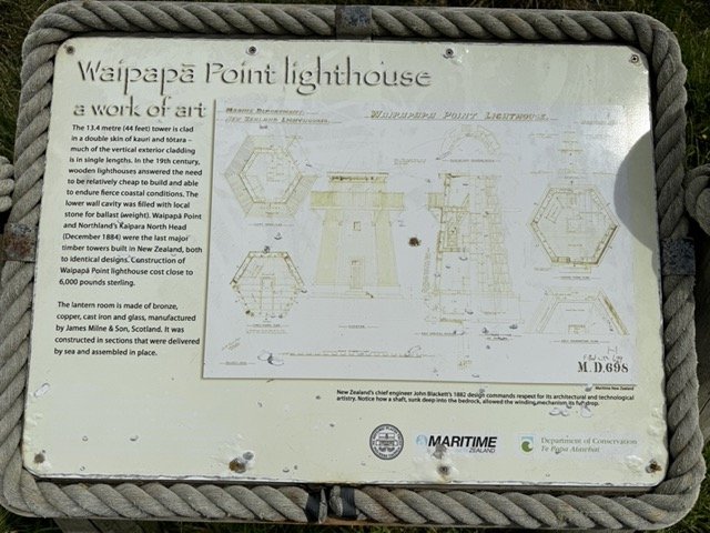
We stopped at Waipapa Point Lighthouse and happened to park next to an older couple from Loveland, Colorado - small world! All of these lighthouses from the late 1800s are really cool. It’s amazing to think how critical the lighthouse keepers role was to all ships during the booming shipping industry. At this lighthouse they had the engineering drawing copied on the sign so you could see the schematic from 1882. As you can imagine, we both loved seeing that.

Our lighthouse tour continued as we aimed to visit Nugget Point Lighthouse at sunrise. We camped nearby and had the most unexpected, beautiful roadside sunset.


Even more spectacular though was the sunrise at Nugget Point. The colors were so vibrant in all directions around the lighthouse and the light rays were stunning.


We continued north to Dunedin where we looked for some of the places we went on a weekend to Dunedin in college. We found a bunch of them and had fun sending pictures back to Adam, Nate, Zach, and McCall. We didn’t experience a lot of Dunedin in the daytime last time so we loved seeing the beaches and surfing around the city. We ate donuts at this beautiful park overlooking the ocean and walked around the Octagon in the center of the city.
The last stop of what became a full-on lighthouse tour was Katiki Lighthouse. I also read that it was a great spot to see penguins, but unfortunately we left seeing zero penguins this time.
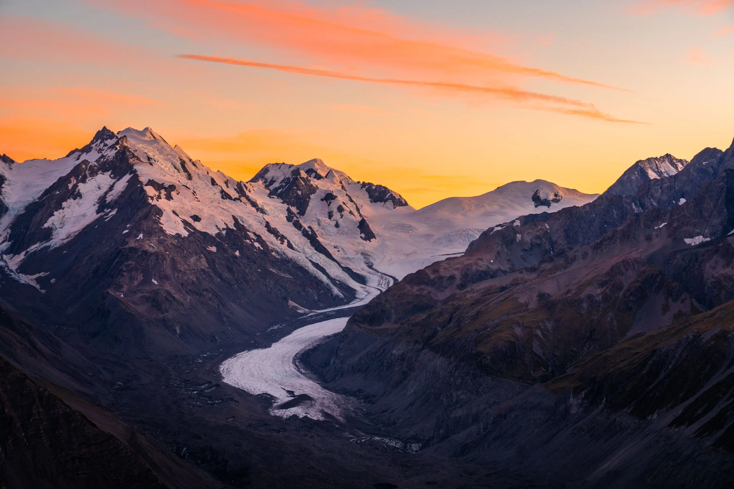
We felt fully rested after several days on the South coast and were ready to get back into our regularly scheduled programming of lots of backpacking. My leg was feeling great after the little hiccup on the Earnslaw Burn hike so we decided to maximize a weather window in Aoraki/Mt. Cook National Park and do our most anticipated hike of the trip. Our drive to Mt. Cook was more eventful than we expected with 120 km/hr gusting cross winds. Grady was turning the wheel strongly to the left and still getting blown to the right. We checked the forecast to make sure nothing had changed with the weather given light winds are key for our itinerary and it still looked calmer the next few days. We kept our fingers crossed.
The Ball Pass Crossing in Mt. Cook is an off-trail mountaineering route through high alpine areas surrounding Mt. Cook. There aren’t many people who do it, but for those who know of it and have the abilities to climb it - many regard it as the crown jewel of New Zealand. We had done a ton of research and felt like it was within our abilities, but would be a challenge. We set off on the Hooker Valley track along with hundreds of other people around 9 am, but we quickly became the only ones in sight once we passed the lake and left the trail.


We navigated the scree fields, boulders, and bushes of the slopes surrounding the hooker lake. We had to take extra care to avoid these really prickly bushes. They don’t look scary, but they hurt a bunch!


The route used to be more defined, but there’s been a rapidly changing landscape there with tons of erosion. Four enormous landslides completely wiped out huge chunks of the lateral moraine and force climbers to go up and around the slides. There are currently still safe ways to navigate them, but if the erosion continues at this rate - the route may soon be impassable. We felt relieved as we finally neared the head of the lake and the base of the glacier.


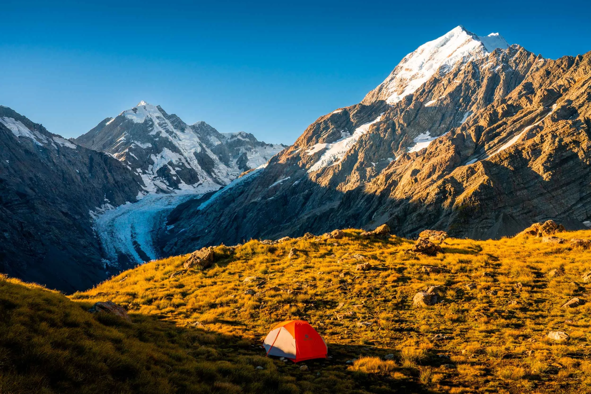
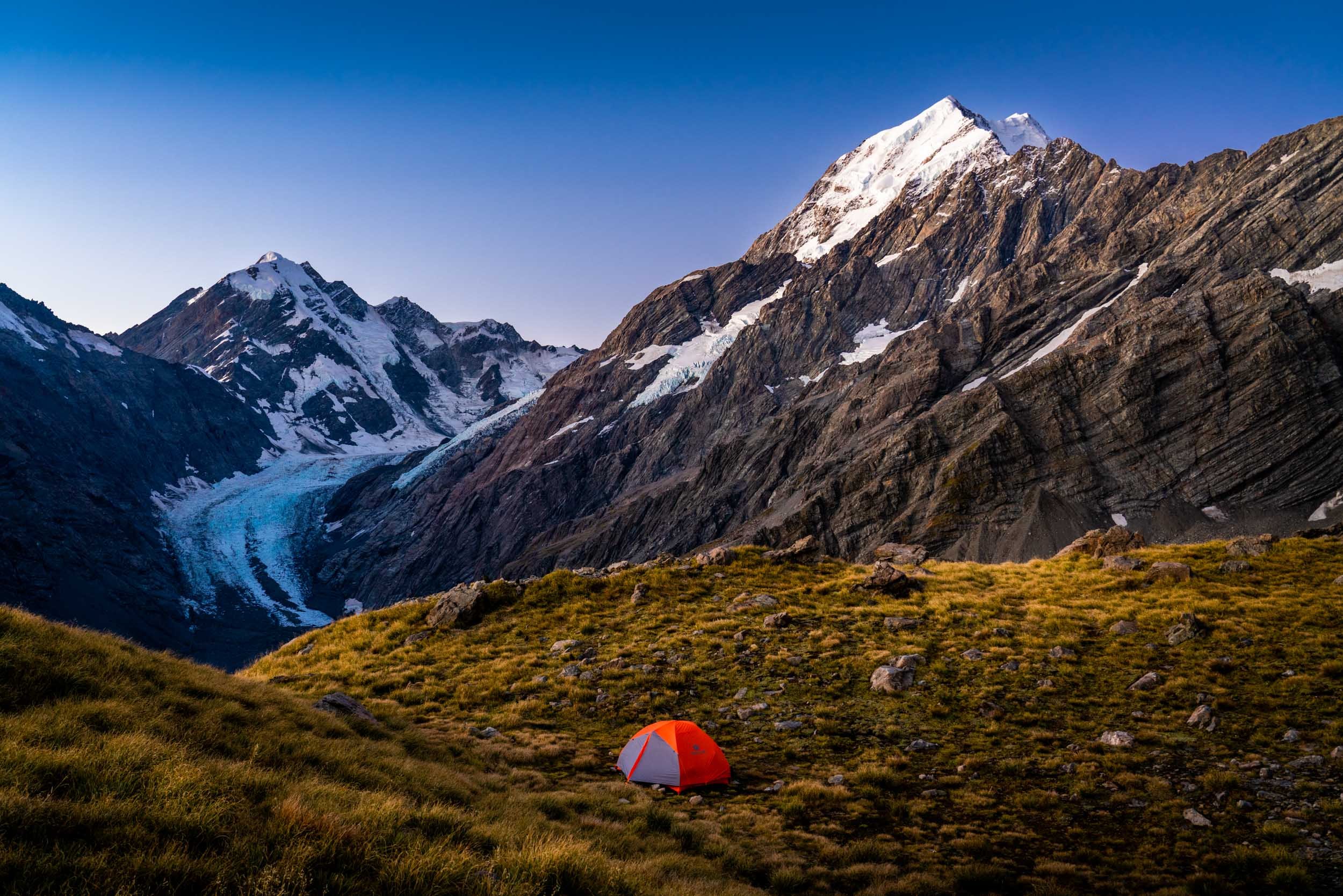
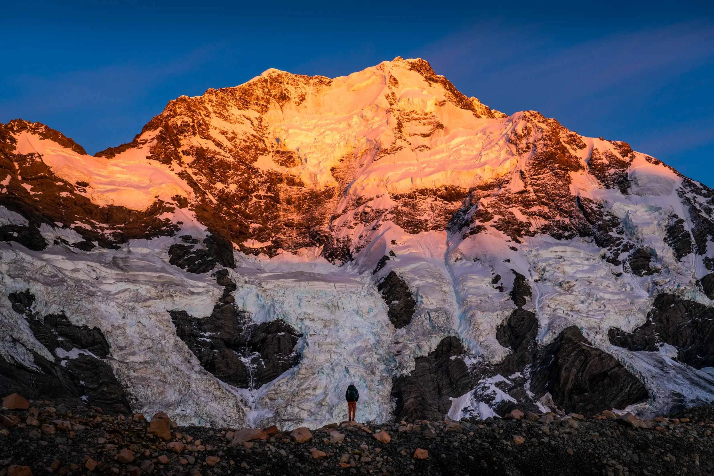
Our plan was to camp at “The Playing Field” which is a nice flat area in the high alpine overlooking the Hooker Glacier, Mt. Cook, and Mt. Sefton. We could see our destination for a lot of the day, but it started to become more clear as we neared “The Gut”. This steep couloir of a boulder field was supposed to be the most challenging part of the day, but honestly - navigating the landslide paths was more difficult. Even though we had gotten great beta on the landslides and knew they’d only be passable at the very top, we were still surprised by how loose and exposed they were. The larger landslides had near vertical walls hundreds of feet high. The scale of the erosion was unsettling and navigating the terrain around them was really difficult.


Grady was concerned about finding water up at the playing field (I was not) so he filled up water at a lower waterfall and schlepped more than 10 lbs of water nearly 2000 vertical feet up “the Gut”. I felt like the waterfalls would continue and sure enough, there was flowing water within 2 minutes of our campsite. At least we were uber prepared.
We were so happy to reach the top and the views totally blew us away. It had been a really challenging day with constant mental focus on each footstep, but all worth it to relax up here.
The relaxation only lasted for a few minutes though until the Keas found us. We set up our tent and quickly discovered that there was a big bone of an animal right next to it.
That was a bit alarming, but definitely made us curious. We used a rock to move it further from camp, but started seeing a trail of more bones. It looks like a sheep or goat maybe died up on the plateau and the Kea have been cleaning up, scattering the bones along the way. They will eat literally anything.
A few started circling over head and it seemed like they were calling out for their friends to join them. Before we knew it, 13 were surrounding us and our tent.


We were outnumbered. Any time we walked away from the tent or our gear, they approached. We couldn’t stop thinking of this horror story we heard of another tramper in a different alpine area of New Zealand. They woke up to a Kea that had chewed through their tent and was actively eating their sleeping bag - while they were in it. It wasn’t seeming like we’d get any sleep that night.

Grady wandered a bit away from camp to take sunset photos, but I couldn’t join him. One of us had to defend the tent at all times. The tricky thing was that he left my phone on a tripod taking a Timelapse just far enough away from the tent that it was out of sight. I tried to defend both areas from the Kea, scaring them away as they started to rush towards gear, but they are smart birds and split up into equal groups. At one point, I was in a stakeout with 6 of them around the tent and 5 others were nibbling on the tripod.

We rescued all gear and put everything inside the tent, against our Colorado bear instincts. While there aren’t bears to worry about here, even the “mini bears” of the western US like marmots and porcupines were starting to sound friendly in comparison to the relentless Kea.
The Keas surrounded the tent so we decided to sleep in shifts. Good news is they calmed down by about 2 am, but at 6 am they were back in full fury. While Grady took sunrise photos, I packed up the tent to get all of our gear safely stashed in backpacks. The sunrise was spectacular.


The Keas were swooping overhead in a sort of show in front of Mt. Cook. I asked Grady after this experience if Kea were still his favorite animal to which he said, “Yes, although I now respect and fear them”…
The beauty of the views made the tiring Kea experience worth it. It was one of the least pleasant camping experiences, but most beautiful views - an almost otherwise impossible combination. We were just hoping there would be no Kea at the next camping spot.
When we started hiking at 9:00 am the sun still hadn’t hit our campsite, thanks to the steep ridge line to the east that we would soon need to negotiate. It was cold as we climbed up the “Z” - a prominent feature on this route. You ascend this rock face in a “Z” formation to make sure you exit at just the right spot to catch the ridge behind it without being greeted by cliffs. Once we exited the “Z” we could see Ball Pass which was the next objective and the high point on our route.


It looked intimidating from a distance, but like most mountains - it looked much more manageable when we got closer. This section wasn’t trivial though and the trip reports we had read didn’t seem to talk a lot about the scree to traverse here.
After a lot of careful footsteps and some slogging up the rocks, we finally made it to Ball Pass. On our final ascent up the pass we saw the first other people on our route. It was an older Kiwi couple and the woman had guided this route a bunch 25 years ago. It was reassuring to see we were taking the same route as them, but also saddening to hear how much this route has changed in 25 years. She shared that the recession of the glacier is causing more instability in the moraine and with water flowing where ice was, it yields more landslides and erosion.
Climbing the pass involves going up the glacier, but the snow was completely melted. It was loose scree on dirt and glacial ice below. We didn’t even need to put micro spikes on for this section.
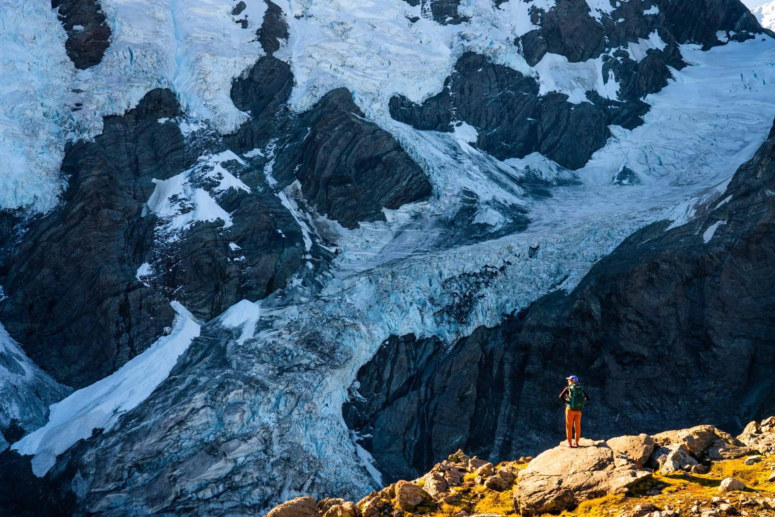
The last few footsteps up to the top of the pass were loose and a bit of a one step forward, two steps back feeling, but as we crested the pass, the reveal of the other side was amazing. We were both initially speechless as we saw the vista before us. The Caroline Face of Mt Cook dominated the scene with its imposing 2500m face of near vertical rock and ice above us, while smaller glaciated peaks stood behind surrounding the 23.5 km long Tasman Glacier. I’m confident that no pictures can do this view justice, and we both said this was likely the most beautiful single view either of us has seen.


We had lunch at the top of the pass before descending the glacier on the other side. This time we would need to go across the snow, but we had researched it ahead of time and knew our route wasn’t crevassed and would just require walking with traction. It ended up being a bit steeper than we thought, but also a bit easier because the snow was quite soft. We were able to slide down the slope safely which was way more fun than walking down!
The glacial tarns at the base of the snowfield were spectacular. We filled up our water bottles directly with the water that looked like Glacier Frost Gatorade. It tasted so clear and refreshing.

We knew the next bit of the route would be challenging as we would be traversing a ridge the entire way to Caroline Hut. This part of the route was mostly marked with cairns, but they’re hard to see because it’s a little stack of rocks in a big field of rocks. It’s easy to see the cairns right in front of you, but more challenging to see them in the distance or if you’re slightly off track (us).


The ridge was basically a bunch of spires in a row that created a ridge-like formation. If you take the wrong route you get cliffed out and have to turn around. The safe route is *mostly* marked by cairns and requires you to ascend / descend the ridge repeatedly - making it kind of complex to navigate.


It was spectacular though as we continued along the ridge and saw more and more of the Caroline face.

It’s just such an impressive face of a mountain with the huge glaciers and ice fall. It’s known to be one of the most difficult routes to climb of Mt. Cook and I can’t imagine how anyone would climb it. It’s a beautiful and intimidating view of a mountain.
We finally made it to the Caroline Hut where we filled up water. There was supposed to be water available in a tank there, but even still Grady was so relieved to see water flowing. The water fear held firm to day 2 and he again filled up 10+ lbs of water. This time it was the right call. We decided to press forward a bit further to go to a campsite with a more open view of the Caroline Face and the Tasman Glacier. We couldn’t be happier we did.
This was the most beautiful campsite I think we’ve ever had with just complete panoramic views surrounded by huge glaciers.
The scale of everything is hard to convey, but Mt. Cook was 7000 feet above us in these photos. It was a surreal feeling to be so close to such huge mountains and glaciers. We felt tiny.


The cloudless sunset cast a beautiful orange color on the peaks, but the moon made it even better when it showed up perfectly nestled between the mountains.


After the difficulty of the last two days of hiking I think we appreciated this experience so much more. We felt grateful to be able to do this, to experience it, and that we challenged ourselves to do something that was a little outside of our comfort zone.
We went to sleep enjoying the peace and quiet of no Keas. It’s amazing how much better a camping experience can be just when you don’t have to defend your tent!
The next morning was supposed to be cloudy. The weather for this 3-day window looked perfect for this trek with the only blip being a cloudy Thursday morning. When we woke up at 6, we were so happy for the forecast to be wrong. The sunrise was even more colorful and beautiful than the sunset of the night before.


The only other way to see these glaciers is via helicopter. Helicopter tours are a totally different, unique way to see them because it’s far more dynamic in that you get to see a lot more in a short amount of time. The downside is they only run short flights during normal daylight hours so you miss out on the beauty of sunrise and sunset. There’s something really special about hiking over a pass and seeing a new view for the first time, but even more so getting to experience these places in different ways than most people. We hiked for 3 days to see several more static views, but the quietness and beauty of all the different lighting conditions make it so worth it.


We slowly packed up camp and began our descent. We continued along the ridge for quite a while - up and down to follow the semblance of a track.
The ridge separates two different glaciers. Even though some of the terrain looks grey and doesn’t resemble a glacier, it still is one. The quintessential white ice is under those rocks, all piled up from debris of erosion around the glaciers.


Finally, we rounded the corner as we left the ridge and saw Ball Hut. We felt a sigh of relief because we’d been told it was a “walk out” from Ball Hut other than one big landslide to negotiate. The ranger said that the landslide should be no big deal compared to everything we would have already done by this point.
He was right, but the size of the landslide was humbling. The walls were sheer vertical faces of unstable scree that rose many hundreds of feet from the break at the ground. We had to follow a track through the “bush” (forest), up and down several fixed ropes to access the upper part of the slide that was safe to cross.


This part of the hike from Ball Hut to the parking lot is a track not a route so it was really well marked and yielded what felt like an actual trail. It was comforting. On the contrary we saw several day-hikers trying to reach Ball Hut who were astonished by the poor condition of the track and the difficulty of the landslide navigation. It put things into perspective for all we’d done already to reach this point in the traverse.
We saw two climbers heading up with a guide presumably to do the guided adaptation of the Ball Pass Crossing. The guided companies no longer take clients up the Hooker Valley due to the near impassibility of the landslides so they unfortunately don’t get to do the traditional crossing in full. The funny part was that they were wearing full climbing harnesses and helmets while walking up the track to Ball Hut. I’m sure it’s a safety and liability thing, but it was funny to see it on the easiest part of the track where it’s just a bit of rock walking and at a time of year where that gear isn’t required on the route no less.
The last hurdle to navigate for this crossing was the hitchhike back to the other car park (parking lot) at the end. Our car was parked on the Hooker Valley Trail side and we were exiting the Tasman Glacier side. Our feet were tired and a late lunch was beckoning us so Grady scurried ahead to see if he could catch a ride and swing back to pick me up. Thankfully, there was a nice German guy hiking out at the time who kindly gave Grady a ride.
Soon, Grady swung back around to pick me up and we were off to the DOC visitor center to check ourselves back in. They operate an “intentions” system so you notify them if you’re going out in the backcountry, your route, and when you expect to back. When you return, you check yourself back in so they know you’re safe. It’s quite comforting!
We found a pub in Twizel that had Speights beer & hot sandwiches and celebrated completing the best route of the trip to date. We felt like this route hit a sweet spot - we never felt unsafe or that it was above our skill levels, but it challenged us the entire time. That alone felt worth celebrating even independent of the remote beauty of the route.

We camped overlooking Lake Pukaki and had another amazing roadside sunset. It’s one of the best freedom camping sites we’ve been to.

It’s time for a little R&R before we hit the trails again. We’re heading to Wanaka to rest a bit and then hope to head back towards Milford Sound next week. We have a backpacking trip we want to do down there that will be very different than the last time we were in that area. We’ll share more soon!
Some new words and expressions of the past few weeks: How did you find it? (What’d you think of it?), How are you going? (How are you doing?), Wops (Backcountry/remote area), Car park (parking lot), Bush (forest), Laundrette (laundromat), and Cuppa (hot beverage)